
Ever dreamt of capturing the world from a bird's-eye view, unlocking perspectives impossible from the ground? This isn't just a dream; it's a call to adventure! Join me as we explore the most magnificent, legally permissible drone photography locations on Earth, complete with personal tales and essential tips to elevate your aerial game. ---
Chasing the Horizon: My Quest for the World's Most Epic Drone Shots
There’s a moment that every drone pilot lives for. It’s that split second when your bird takes flight, ascends, and suddenly, the familiar world below transforms into something utterly alien and spectacular. The ground-level perspective, no matter how grand, simply cannot compete with the sheer awe of an aerial vista. My journey into drone photography started almost five years ago, after a particularly frustrating trip where I just knew there was a better shot of a cascading waterfall, a winding river, a sprawling city. I bought my first drone, a modest DJI Mavic Mini, and the world quite literally opened up beneath me.
I remember my first truly epic shot. It was a sunrise over a misty valley in Slovenia. The drone was just a tiny speck against the vast canvas of the sky, but through its lens, I was seeing a painting unfold. My heart pounded with excitement, a mix of adrenaline and pure creative joy. That feeling, that insatiable desire to find the next breathtaking view, has propelled me across continents, navigating ever-changing regulations and chasing the perfect light.
But here’s the kicker: not all epic locations welcome drones with open arms. Regulations are a constantly shifting beast, and responsible flying is paramount. That’s why I've dedicated countless hours to researching, visiting, and, yes, sometimes even getting permission from local authorities to bring you this curated list. These aren't just pretty places; these are places where, with careful planning and respect for the rules, you can unleash your drone and capture images that will truly make your portfolio sing. So, pack your batteries, check your propellers, and prepare for an adventure – these are the drone photography locations you absolutely need to experience before you die!
---
1. Iceland: Where Fire Meets Ice and Drones Reign Supreme
Why it's a Drone Pilot's Dream: Iceland is, without a doubt, a drone paradise. Its raw, untamed landscapes – from black sand beaches pounded by Atlantic waves to colossal waterfalls, volcanic craters, and vast glacial lagoons – were practically designed for aerial photography. The sheer scale and dramatic contrasts are best appreciated from above.
My Personal Glimpse: I’ll never forget my first time flying over Reynisfjara Black Sand Beach. The basalt columns rising majestically from the ebony sands, the powerful waves crashing against them, and the iconic Reynisdrangar sea stacks jutting out from the ocean – it was cinematic. I flew my Mavic 3 out over the waves (respectfully distant from the treacherous sneaker waves, of course), capturing the white foam against the dark sand, the symmetrical patterns of the retreating water, and the sheer power of nature. It wasn't just a photo; it was an experience, a visceral connection to the wild heart of the island. Another highlight was Skógafoss, where I managed to capture the full arc of a rainbow over the waterfall from an angle no human could ever reach on foot. Pure magic!
Practical Tips & Logistics:
- Best Time to Fly: Summer (June-August) offers long daylight hours and milder weather, but shoulder seasons (May, September-October) can provide dramatic light and fewer crowds. Winter offers stunning snowscapes but challenging conditions.
- Regulations: Iceland is generally drone-friendly, but strict rules apply in national parks (Vatnajökull, Snæfellsjökull, Þingvellir), nature reserves, and near airports. Always check the Icelandic Transport Authority (ICETRA) website for the latest regulations. Respect privacy and give wildlife (especially nesting birds) a wide berth. Many popular tourist spots have signage indicating drone restrictions.
- Gear: Wide-angle lens, ND filters (essential for waterfalls and bright days), extra batteries (cold weather drains them fast), and a sturdy tripod for ground shots.
- Permits & Access: Generally, no specific permit is required for recreational flying outside restricted areas. However, some private landowners or specific attractions might require permission or have their own rules. Always look for signage.
- Costs: Flights to Iceland can vary, but accommodation and rental cars are major expenses. Budget around $150-300+ per night for mid-range lodging and $60-100+ per day for a rental car (essential for exploring).
- Instagram-Worthy Shot: A sweeping panorama of Reynisfjara with the sea stacks, or an aerial view of Skógafoss with a rainbow.
---
2. The Faroe Islands: A Drama of Cliffs and Cloud-Kissed Peaks
Why it's a Drone Pilot's Dream: Perched in the North Atlantic, the Faroe Islands are a realm of dramatic cliffs, emerald green valleys, turf-roofed houses, and an ever-present sense of wild beauty. The verticality of the landscape, the remote isolation, and the frequent mist make it an extraordinary canvas for aerial storytelling.
My Personal Glimpse: I remember the sheer exhilaration of flying my drone along the cliffs of Vágar, near the famous Múlafossur waterfall. The drone hovered, capturing the tiny village of Gásadalur nestled against the towering cliffs, with the waterfall plunging directly into the ocean. The wind was fierce, and my heart was in my throat, but the footage was unreal – a testament to the raw power of nature. Another unforgettable moment was flying over the iconic Drangarnir sea arch, where the drone allowed me to frame the arch perfectly against the churning sea, revealing its true grandeur in a way no ground shot ever could.
Practical Tips & Logistics:
- Best Time to Fly: Summer (June-August) offers the most stable weather and longer daylight. Expect wind and rain at any time of year.
- Regulations: Drones are generally allowed, but strict rules apply. You must register your drone if it weighs over 250g. No-fly zones include airports, military installations, and populated areas. Always respect privacy and keep a safe distance from people and wildlife (especially nesting seabirds on cliffs). Many popular spots (like the path to Sørvágsvatn/Leitisvatn, the "floating lake") have restricted drone zones. Check the Faroese Civil Aviation Administration for detailed rules.
- Gear: A reliable drone with good wind resistance is crucial. ND filters are a must for capturing the moody skies and slow-shutter effects on waterfalls. Waterproof gear for yourself and your drone bag is highly recommended.
- Permits & Access: Generally, no specific permits are needed for recreational flying, but some popular hiking trails and viewpoints are on private land and may require a fee to access. Always check local signage.
- Costs: Flights to the Faroes can be pricey. Accommodation (hotels, guesthouses, Airbnb) ranges from $100-250+ per night. A rental car is essential for exploration, costing around $70-120+ per day.
- Instagram-Worthy Shot: Múlafossur waterfall plunging into the ocean from above, or a sweeping shot of Drangarnir sea arch.
---
3. The Dolomites, Italy: Alpine Majesty from the Sky
Why it's a Drone Pilot's Dream: The Dolomites, a UNESCO World Heritage site, are a symphony of jagged limestone peaks, emerald alpine lakes, and verdant valleys. While many national parks within the Dolomites have strict drone restrictions, there are numerous areas just outside these boundaries, or specific spots with clear permissions, that offer unparalleled aerial views of these majestic mountains.
My Personal Glimpse: I remember waking up before dawn, the air crisp and cold, heading to a spot near Tre Cime di Lavaredo (just outside the restricted park zone, mind you!) to catch the sunrise. As my drone ascended, the first rays of sun kissed the iconic three peaks, painting them in hues of orange and pink. It was breathtaking. Another morning, I flew over Lago di Braies (with careful respect for the crowds and local rules, as it's a very popular spot), capturing the reflection of the surrounding peaks in its still, turquoise waters. The drone allowed me to show the sheer scale of the mountains embracing the lake, a perspective impossible from the crowded shoreline.
Practical Tips & Logistics:
- Best Time to Fly: Late spring (May-June) for wildflowers and melting snow, or early autumn (September-October) for golden larches and crisp air. Summer can be busy.
- Regulations: Italy has clear drone regulations. You must register your drone (if over 250g), have insurance, and obtain an ENAC ID. Flying is prohibited over populated areas, near airports, and in many national parks and protected areas. Always check local signage and the ENAC (Italian Civil Aviation Authority) website. For specific locations like Lago di Braies, be extremely mindful of people and follow any local rules.
- Gear: A drone with good camera stability for crisp mountain shots. ND filters for lake reflections and any potential waterfalls. Extra batteries, as high altitude and cold can affect performance.
- Permits & Access: Generally, no specific permits are required for recreational flying outside restricted zones, provided you adhere to national regulations. Some private land or specific tourist sites might have their own rules.
- Costs: Accommodation ranges from $80-250+ per night. A rental car is highly recommended for exploring, costing around $40-80+ per day. Gondola/cable car fees can add up if you use them to access higher viewpoints.
- Instagram-Worthy Shot: Sunrise over Tre Cime di Lavaredo, or an aerial panorama of Lago di Braies with the peaks reflected perfectly.
---
4. Cappadocia, Turkey: A Fairytale Balloon Ballet
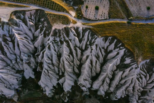
Why it's a Drone Pilot's Dream: Cappadocia is truly a place from a fantasy novel, with its "fairy chimneys" (unique rock formations) and ancient cave dwellings carved into the soft volcanic rock. But what elevates it to a drone pilot's dream is the daily spectacle of hundreds of hot air balloons gracefully ascending at sunrise. Capturing this ballet from above is an experience like no other.
My Personal Glimpse: The first time I witnessed the hot air balloons of Cappadocia, I was on the ground, craning my neck in awe. But the next morning, my drone was up before the first light. As the sun peeked over the horizon, painting the valleys in soft pastels, the balloons began their ascent. My drone, a tiny observer, soared amongst them (at a safe distance and altitude, respecting their flight paths), capturing the surreal sight of dozens, then hundreds, of colorful orbs floating silently above the unique landscape. It felt like I was flying through a dream. The drone allowed me to compose shots that perfectly framed the balloons against the valleys, showing the sheer scale and magic of the moment.
Practical Tips & Logistics:
- Best Time to Fly: Spring (April-May) and Autumn (September-October) offer the most pleasant weather for balloon flights and drone operations.
- Regulations: This is crucial. While drones are generally allowed in Turkey, flying near and around the hot air balloons requires extreme caution and adherence to specific rules. You must register your drone with the Turkish Directorate General of Civil Aviation (DGCA). There are specific no-fly zones, especially near airports and military installations. When flying near balloons, maintain a safe distance, do not interfere with their flight paths, and avoid flying directly above or below them. It’s often best to fly before the main launch or slightly after, or from a vantage point that allows you to capture them in the distance without being a hazard. Always check local guidelines provided by tour operators or local authorities.
- Gear: A drone with excellent low-light performance is beneficial for sunrise shots. ND filters for bright conditions once the sun is fully up. Plenty of batteries.
- Permits & Access: Your DGCA registration is key. No additional permits are typically required for recreational flying outside restricted areas. However, some private viewing spots might have rules.
- Costs: Hot air balloon rides themselves are expensive ($150-300+), but you don't need to be in one to film them. Accommodation in Göreme or Ürgüp ranges from $50-150+ per night. Car rental is optional; many tours and taxis are available.
- Instagram-Worthy Shot: A wide shot of dozens of hot air balloons floating over the fairy chimneys at sunrise, captured from a slightly elevated vantage point.
---
5. Moab, Utah, USA: Red Rock Wonderland
Why it's a Drone Pilot's Dream: While U.S. National Parks are largely no-drone zones, the vast expanse of Bureau of Land Management (BLM) land and certain state parks surrounding Moab, Utah, offer an incredible playground for drone pilots. The iconic red rock formations, deep canyons, and winding rivers like the Colorado provide endless opportunities for dramatic aerial compositions.
My Personal Glimpse: I remember the sheer scale of the landscape as I launched my drone from a designated spot near Dead Horse Point State Park. The winding gooseneck of the Colorado River, carved deep into the canyon floor, was a sight to behold. From above, the intricate patterns of the rock strata and the vibrant contrast of the red earth against the green river were mesmerizing. It was like flying over a giant, ancient sculpture. I spent hours exploring different angles, feeling like an adventurer discovering a lost world. The drone allowed me to capture the vastness and geological wonder in a way that ground-level photography simply couldn't convey.
Practical Tips & Logistics:
- Best Time to Fly: Spring (March-May) and Fall (September-November) offer pleasant temperatures and stunning light. Summer can be extremely hot.
- Regulations: This is critical for the USA. National Parks (Arches, Canyonlands) are strict no-fly zones. However, drones are generally permitted on BLM land, provided you follow FAA regulations (registration, Part 107 if commercial, recreational rules if recreational). Dead Horse Point State Park does allow drones in specific designated areas and times, but always check their current policies before flying. Always avoid flying over people, private property, and respect wildlife.
- Gear: A drone with good battery life is essential for covering vast distances. Polarizing filters can reduce glare on rocks and water.
- Permits & Access: For recreational flying on BLM land, you typically don't need a specific permit beyond your FAA registration. For state parks like Dead Horse Point, there's a park entrance fee (around $20 per vehicle), and you must adhere to their specific drone policies.
- Costs: Accommodation in Moab ranges from $100-300+ per night. A high-clearance 4x4 rental is often recommended for accessing remote trails, costing $80-150+ per day.
- Instagram-Worthy Shot: A wide-angle shot of the Colorado River snaking through the canyons from Dead Horse Point, or a unique angle of a specific rock formation on BLM land.
---
6. Patagonia (Argentina/Chile): The Wild South
Why it's a Drone Pilot's Dream: Patagonia, at the southern tip of South America, is a land of towering granite spires, colossal glaciers, vast steppes, and pristine lakes. While iconic national parks like Torres del Paine and Los Glaciares have very strict drone rules (often outright bans), the sheer scale of the region means there are still breathtaking, legally permissible areas to fly, particularly outside the core protected zones or on specific private properties with permission.
My Personal Glimpse: My Patagonian drone adventure was perhaps the most challenging, but also the most rewarding. I focused on areas around Ushuaia, Argentina, rather than inside the national park itself. I remember flying my drone over the Beagle Channel, capturing the rugged coastline, the snow-capped peaks in the distance, and the deep blue of the water. The wind was relentless, a constant battle, but the payoff was incredible – a perspective of "The End of the World" that felt truly wild and untamed. Another time, near El Chaltén, after extensive research and securing permission from a local estancia owner, I captured the vastness of the steppe leading up to the Fitz Roy range from a distant, permissible vantage point. It wasn't the close-up of Fitz Roy I initially dreamed of, but the sweeping panorama of the landscape leading to it, under a dramatic sky, was just as powerful.
Practical Tips & Logistics:
- Best Time to Fly: Austral summer (December-March) offers the most stable weather, but expect high winds. Shoulder seasons (November, April) can be beautiful but less predictable.
- Regulations: This region has some of the strictest drone regulations globally, especially within national parks (e.g., Torres del Paine, Los Glaciares National Parks have outright bans). It is absolutely crucial to research country-specific (Argentina ANAC, Chile DGAC) and local regulations for the exact area you plan to visit. Flying without proper authorization in restricted areas can lead to significant fines and drone confiscation. Focus on areas outside national park boundaries or obtain explicit permission from private landowners.
- Gear: A drone with excellent wind resistance is non-negotiable. ND filters for bright glaciers and skies. Multiple batteries (cold and wind drain them faster). A robust, waterproof case for transport.
- Permits & Access: Recreational drone flying in Argentina and Chile generally requires registration with their respective civil aviation authorities. For national parks, assume a ban unless explicitly stated otherwise with a permit. For private lands, always seek permission.
- Costs: Patagonia is an expensive destination. Flights, accommodation ($100-300+ per night), and transportation (rental cars $80-150+ per day, or guided tours) can add up quickly.
- Instagram-Worthy Shot: A wide-angle shot of the Beagle Channel and surrounding mountains near Ushuaia, or a dramatic panorama of the Patagonian steppe leading towards a distant mountain range.
---
Elevate Your Game: Essential Drone Photography Tips for the Adventurous Soul
Beyond just finding the right location, mastering the art of drone photography requires skill, patience, and a healthy dose of respect. Here are my top tips to ensure your aerial adventures are both successful and responsible:
- Research, Research, Research (Then Research Again!): I cannot stress this enough. Regulations change, and what was allowed last year might be forbidden today. Before every trip, check the civil aviation authority website for the country/region, park websites, and local tourism boards. Look for "No Drone Zone" signs on the ground. When in doubt, ask locals or park rangers. It's better to be safe than sorry (and fined!).
- Master Your Drone: Know your drone's capabilities and limitations. Practice flying in various conditions (wind, different light) before you head to an epic location. Understand your camera settings (manual mode is your friend!).
- Prioritize Safety & Respect:
- People: Never fly over crowds or private property without explicit permission. Respect privacy.
- Wildlife: Maintain a safe distance from animals, especially nesting birds or sensitive species. Your drone can cause stress or disturbance.
- Environment: Don't fly in conditions that could damage your drone or create a hazard (e.g., strong winds, heavy rain).
- Airspace: Stay away from airports, helipads, and military installations.
- Battery Management is Key: Cold weather significantly reduces battery life. Keep batteries warm in your pockets until just before launch. Always carry more batteries than you think you'll need.
- Pre-Flight Checklist: Before every flight, visually inspect your drone (props, arms, camera). Check GPS signal, compass calibration, and return-to-home point. Ensure you have enough storage space on your SD card.
- ND Filters are Your Best Friend: Neutral Density (ND) filters are essential for controlling exposure in bright conditions, allowing for cinematic motion blur in videos and richer colors in photos.
- Composition & Storytelling: Don't just fly high. Think about your shot. What story are you trying to tell? Use leading lines, rule of thirds, and varying altitudes to create dynamic compositions. Look for unique patterns, textures, and scales that only a drone can capture.
- Post-Processing Power: The raw files from your drone contain a wealth of information. Learn to use editing software (Lightroom, Photoshop, DaVinci Resolve) to bring out the true potential of your images and videos.
- Insurance: Invest in drone insurance. Accidents happen, and it's better to be covered for damage or liability.
---
The Sky Awaits: Your Next Aerial Adventure
The world is a vast, beautiful canvas, and with a drone, you hold the paintbrush to create truly unique masterpieces. The locations I’ve shared are more than just places; they are experiences that will challenge your skills, ignite your creativity, and leave you with memories (and photos!) that will last a lifetime. Each flight is an opportunity to see the familiar anew, to connect with our planet from an extraordinary vantage point.
So, what are you waiting for? Start planning your next epic drone adventure. Research those regulations, pack your gear, and prepare to chase the horizon. The world from above is calling, and it's an invitation you won't want to miss.
Which of these drone spots is calling your name? Or do you have a hidden gem you’ve legally flown at? Share your thoughts and dream destinations in the comments below! Let's inspire each other to explore the world from new heights!
---
More pictures

Tags
Share this guide
We may earn a commission if you click a link and buy a product or service, at no extra cost to you. How affiliate links work.
Been there?